How does Niantic calculate MU captured by fields? This is a question many players seem to ask. I did try to google answers – but didn’t come up with any clear data.
A recent reddit article tried to do some refinements based on old data. It looked plausible and got me exited. It left a few open questions that should be very simple to solve as a scientist. So I went out and gathered some data myself – and pretty quickly found out – it isn’t that simple. My own data started to contradict itself pretty quickly.
I therefore set out to do my own private operation – operation 47debb3.
What we agree on
- The larger the field, the more mind units are captured
- You get more mind units in denser populations / cities
What else do we know?
- Large fields covering smaller fields can have less MU captured
- MU captured across water / with ankers in remote areas is low
What we speculate
- MU calculation depends on the anker points of the field
- MU calculation depends on S2 fields
- S2 level 10-12 are mentioned as likely contender
The work prior to operation 47debb3
It should be very easy to verify if S2 cells are responsible for the MU captured. If MU indeed is dependent on size of the field as well as the cell, then all fields in a given S2 cell should have the same MU density per square km.
All that is needed: make some fields, jot down the MU captured, calculate the size of the field and find the ratio aka the density.
I did exactly that. Went out, generated some fields in my local S10 cell. Looked at densities. Results varied did go from 107-234. So I went to look at S11 cells – still values that varied too much. So down to my local S12 cell. Values got closer – but I still had values from 160-230. And my fields started to get too small – possible rounding errors could creep in. It also might not help that one anker in my S12 cell is ‘in the sea’. It is the end of a 300m pier. Yes – you guessed it – that one showed the lowest values.
I needed a better data set.
The idea behind operation 47debb3
I looked at a close by S12 cell that could be completely covered with fields large enough to minimise rounding issues. Assuming a density of 200+ MU/km2 means I would need individual fields of approximate 0.5 km. I would need enough portals in that cell to be able to cover it more or less equally. I would add a single layer to it for additional data. All smaller cells would have larger error margings – but they might be able to show directions of any trends if the data would not fit.
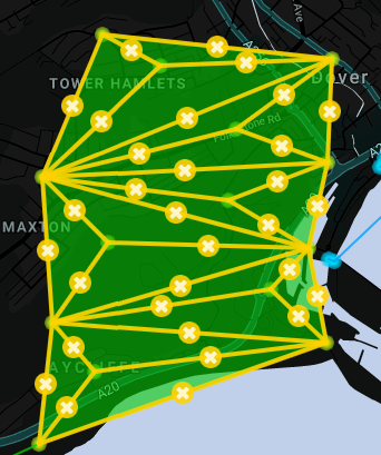
Cell 47debb3 – covering parts of Dover, UK seemed to fit the bill perfectly. Less than 20 min drive to a parking spot in that cell. I have been there before – so know the area well enough. There were still a few portals I never went to – that means a few uniques as bonus.
The cell tends to be not very active – I don’t want interuptions. Not much clearing needs. Actually – just 3 portals needed clearing. 2 of these I wanted to use as anker points – one was used for a long blocking link north and I would do ENL a favour taking that one out.
The operation itself
I had a list of portals and keys needed. I had a backpack with some drinks and power-pack. Also a clip-board – I will take notes both on paper as well as screenshots. Sturdy shoes and a enough time. Two portals in the middle (Western Heights) seemed difficult to reach – I therefore decided to go for these first.
11:58 – I’m parked up and take my first portal (not part of the operation). I would take multiple portals during the day – but would only deploy one (or a few) resonators – never 8 – to ensure I would not accidentally link to the wrong portal.
I immediately run into my first problem. I have the name of the portal and know roughly where it is – but can’t identify it. Luckily I send a intel-link of my plan to the local hangout fielding group. I would return to that one multiple times during the day to look at progress, see my fields slowly turn green, check that I link the correct portal.
It only takes 5 minutes to reach the first portal. Actually with hindsight I should have used a closer parking lot. But you learn. 2 hacks and I have the 3 necessary keys for this portal. Drop Redoubt and East Link Moat done. Onward to the North Moat from the East. This is a picturesque are to walk – just ensure you have good walking shoes as chalk – when wet – can be slippery.
Portal 2 is done quickly as well. I do spot a tiny path down the slope of the hill towards the build up parts of Dover. So I change the plan – leave the car – walk towards the next portal (I had planned to leave the car here). Only a single heat sink used so far. I try to use them sparingly if possible.
I arrive at St Martins church. This one needs 9 links – so the most keys. I’m lucky with my first hack – 2 keys. I throw the first two links and linger around and to get 2 more. This is when I decide to maybe change the plan a little. Does directionality matter? Could I get keys from the inner portals first (only three needed each) and always link from outside in? Off I go towards town – railway station.
My first clearing – my local nemesis has build a tiny field here. Not protected. Low level bursters are enough to clear the portal – build it up – do a single hack. Clearing the remaining portals while waiting for the next hack. 3 keys in a single hack – another portal done.
This is where disaster strikes. I’m off to the next portal – on the way I add some resos to portals I’m not 100% sure I have captured in the past – and the game starts to act very slowly. Bad reception? As it later turns out – global server issues.
The next portal is a nightmare. It takes 2 min to deploy a single reso. Hacking seems not to register at all. Neither Glyph hack nor normal hack. I finally get ‘no items from this hack’. This should be an impossible hack result – as an own fraction one tends to guarantee at least a single reso. I decide to go back and forth between this portal and another one 350 meter away. I slowly build up both portals and manage to get 2 keys – after many attempts – from the most Northwestern portal of the day.
Eventually I manage to have both portals up to 8 resos. And I finally get a single key from the one that caused me most grief. Back to the church – more linking – 2 more keys needed from there as well.
By now I know that the problem is everywhere. Niantic is trying to fix it – but that was only announced in an obscure chat. I’m close to give up – but decide to carry on. ‘Only’ two more keys needed from the church. The first field is up. Hacking still unresponsive. Also capsules don’t work anymore – I try to add the one key I have from that portal – in case it doesn’t register my ‘get key’ command. Doesn’t work – can’t add nor retrieve keys.
In despair I add 1 rare heat sink and 1 rare multihack to the portal. I normal hack with ‘get key’ and pray. Ingress never acknowledges my hacks. Once or twice I get a message – cool down. So something does happen. And eventually I have the two keys in inventory. How often did I hack? I have no idea.
Off to the most Northwestern anchor. My first large field goes up – also my first fully layered one. From here towards Dover harbour. Some nicely layered blue fields. I only need to take out one corner of that for my operation. But who can resist when 2 consecutive XMP8 yield 17k AP and 12k AP. Doing some smashing does offer some variety during the operation.
From here it goes towards Aycliffe. An area that I only was once – very shortly. Finally a few unique portals. Who cares if this means some extra walking. I’m not leaving a unique because it is 50 or 100m of my shortest path.
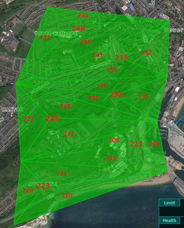
The fields on intel slowly fill out green. I don’t have a spreadsheet – but I can already say they look pretty well behaved and all seem to have the ‘same’ density.
26000 steps – 6 hours, 11 unique portals captured, 24 fields done (once layered). 6 hours total – a really enjoyable day.
The results
Adding the data to a spreadsheet shows that my gut feeling was right. All fields more or less have the same MU density.

Does this data therefore show that MU density is determined on via S2 lvl12 cells? Not that fast. I did the experiment to have a highly accurate dataset. Here is the same data in a slightly different format:
The larger fields should have a mathematical accuracy of +/- 1 MU – assuming rounding only as source of errors. Smaller fields can have errors larger than that.
The northern three larger fields (as well as the 9 layered ones) all fall into that category. They average 233.6 MU with individual values between 231.1 and 236.2. Taking rounding into account all these fields can be described with a single value between 234.6 and 234.9.
Unfortunately the southern three larger fields show a difference that can not be explained by rounding alone. The least dense of these calculates as 211.5 with a lower bound of 210.2 and an upper bound of 212.9.
One of the ankers of these fields Welcome to Dover Marina is more or less surrounded by water. I have seen a similar (but even more pronounced) trends in my own S12 cell – where we have a pier – reaching out 300 m into water. But this is an important anchor across the channel and fields into town block my own play – so I haven;t gathered that much data yet. But it clearly deserves some more data gathering and research.
Conclusion
The MU generated by a field can be calculated with good accuracy using the area of a field and a MU density of the S2 lvl 12 cell for the field.
Some fields yield less MU as expected. This needs more research. Being close to water could be one reason for that – but it is possible that there are other unknown factors that change the MU from a field.
Experimental details
I use Harvesine for distance calculations of each individual link. =ACOS(COS(RADIANS(90-Latitude_1)) COS(RADIANS(90-Latitude_2)) +SIN(RADIANS(90-Latitude_1)) SIN(RADIANS(90-Latitude_2)) COS(RADIANS(Longitude_1-Longitude2)) * 6371
Coordinates of each portal are extracted from the link of the field in the intel map. I copy& paste the link into an excel spreadsheet, automatically extract the coordinates to avoid manual errors and calculate all the info I want. The only other information added manually is the value of MU captured.
The area is calculated using Heron’s formula for the area of a triangle calculated from the lengths of the three sides.
Min and max values: I assume values between 99.5 and 100.5 MU get displayed as 100 MU. I therefore calculate a min value using MU – 0.5 and a max value using MU + 0.5 to get an upper and lower bound. It is possible that Niantic instead uses ceiling or floor as rounding mechanism. This would move my determined value to the end or start of my boundary while the total size of the error margin would still stay pretty much the same.
All ankers are level 5 with 1R8, 1R7, 2R6, 2R5 and 2R4 resonators. All portals are owned by me and where captured during the 6 hours of the operation.
The data for the 24 fields is given below:
| Intel link | Size MU | Density | min | max | Area |
| Field 1 | 20 | 236.2 | 230.3 | 242.1 | 0.085 |
| Field 2 | 34 | 231.6 | 228.2 | 235.0 | 0.147 |
| Field 3 | 62 | 233.9 | 232.0 | 235.8 | 0.265 |
| Field 4 | 117 | 235.6 | 234.6 | 236.6 | 0.497 |
| Field 5 | 30 | 231.1 | 227.2 | 234.9 | 0.130 |
| Field 6 | 32 | 232.2 | 228.6 | 235.9 | 0.138 |
| Field 7 | 37 | 235.1 | 232.0 | 238.3 | 0.157 |
| Field 8 | 100 | 235.3 | 234.1 | 236.5 | 0.425 |
| Field 9 | 31 | 235.0 | 231.2 | 238.7 | 0.132 |
| Field 10 | 26 | 230.8 | 226.3 | 235.2 | 0.113 |
| Field 11 | 24 | 231.0 | 226.2 | 235.8 | 0.104 |
| Field 12 | 82 | 235.3 | 233.9 | 236.7 | 0.349 |
| Field 13 | 42 | 228.4 | 225.7 | 231.1 | 0.184 |
| Field 14 | 29 | 227.4 | 223.5 | 231.3 | 0.128 |
| Field 15 | 53 | 222.3 | 220.2 | 224.4 | 0.238 |
| Field 16 | 124 | 225.5 | 224.6 | 226.4 | 0.550 |
| Field 17 | 23 | 208.6 | 204.1 | 213.1 | 0.110 |
| Field 18 | 13 | 208.8 | 200.8 | 216.9 | 0.062 |
| Field 19 | 42 | 214.0 | 211.5 | 216.6 | 0.196 |
| Field 20 | 78 | 211.5 | 210.2 | 212.9 | 0.369 |
| Field 21 | 40 | 221.2 | 218.4 | 224.0 | 0.181 |
| Field 22 | 19 | 228.2 | 222.2 | 234.2 | 0.083 |
| Field 23 | 49 | 222.8 | 220.5 | 225.0 | 0.220 |
| Field 24 | 108 | 223.1 | 222.1 | 224.1 | 0.484 |
edit: I use side walks region coverer to determine the S2 cell. I have a nagging feeling I do something fatally wrong here as I saw other cells in the past which seemed more diamond shaped.